An AIS transponder helps you to see and be seen in all weather conditions, automatically identifying vessels in your area. But what is AIS and why should you consider installing one in your boat?
An AIS system on-board identifies your boat to other AIS users in the aim of collision avoidance, it can protect your pride and joy from being run down by a large, fast moving ship. Several years ago, (7 years! – Ed) we ran an article introducing AIS technology for recreational boaters. At the time the recreational uptake of AIS was very much in its infancy. Today the world’s leading marine electronics manufacturers offer AIS capability as either an accessory unit or in some cases a standalone system. With ever advancing electronic networking and communications technologies finding their way onto our boats, now is the time to revisit AIS and understand why it is such a hot topic and why so many are installing this safety technology.

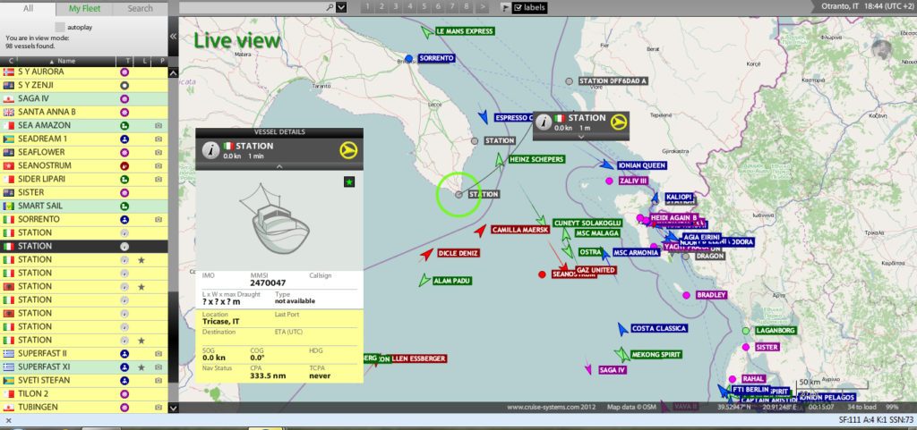
AIS technology identifies every vessel individually, along with its specific position and movements, enabling a virtual picture to be created in real time. Picture a radar-chart plotter display, with overlaid electronic chart data, that includes an icon for every significant vessel within VHF range, each with a velocity vector (showing that vessel’s speed and heading). Each vessel icon reflects the actual size of the ship, with positions accurate to GPS precision. By “clicking” on a ship mark, you can learn the ship’s name, course and speed, classification, call sign, MMSI, and other information. Maneuvering information, closest point of approach (CPA), time to closest point of approach (TCPA) and other navigation data is also available. Information previously visible only to the commercial users is now available to every AIS-equipped vessel.
AIS range is similar to that of your VHF radio, essentially depending on the height of the antenna. Its propagation is slightly better than that of radar, due to the longer wavelength, so it’s possible to “see” over islands if the landmasses are not too high. A typical distance value to be expected at sea is nominally 20 nautical miles (37km). With the help of repeater stations, the coverage for both ship and VTS stations can be improved considerably.
AIS information is not degraded by rain-clutter like radar, so it works the same in all weather. The consensus among safety experts is that AIS is extremely valuable, especially if you travel at night or in crowded harbors with restricted visibility.
AIS data is sent from each vessel every few seconds and contains position and movement information such as course, speed, latitude, longitude, and rate of turn. Static information about the vessel is sent every few minutes and includes the name, type of vessel, length, beam, draft, etc. Nearly all ships are mandated to carry AIS transponders (most commonly Class A) and each year more yachts, launches, powerboats, and smaller commercial boats are fitting AIS equipment (most commonly Class B).
AIS information is typically viewed on a dedicated screen, networked onto a boats plotter, PC or MFD or even via dedicated Apps on a smart phone. Your safety is enhanced day and night, when offshore or in busy marine traffic areas or in bad weather when visibility is reduced. AIS devices are also fitted as Aids to Navigation (eg Virtual marking of navigation hazards) and as portable man overboard devices on individual’s lifejackets for identification amongst AIS equipped vessels.
Interestingly, the US Coast Guard issued new AIS rules in January 2015 requiring nearly all commercial vessels of 65ft (20M) or more operating in US waters to install AIS transponders by March 2016. The subsequent uptake of Class B AIS in the US has reportedly been rapid, simultaneously recreational boaters have seen the advantages of identifying more traffic on the water and installed AIS technology also.
Key AIS equipment
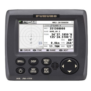
AIS Transponders: An AIS transponder receives and translates the AIS digital radio signals. It also sends AIS signals, making your vessel visible to others with AIS equipment. There are two types of transponders, Class A intended for SOLAS vessels and Class B for fitting on non-SOLAS category vessels. AIS transponders are sometimes referred to as transceivers in the marine industry. Class A transponders models operate at 12.5 watts, offering an average range of 30 nautical miles and are fitted aboard ships with gross tonnage of 300 or more tons. A vessel’s dynamic data, position, speed over ground and course over ground, is taken from the GPS.
The Class A version uses SOTDMA transmission mode, giving it priority over Class B devices. However, it is Class B that is applicable for the recreational and smaller commercial boat market.
AIS Receivers: An AIS receiver operates in the same way as transponder but is a receive only device. If your vessel has a receiver you can view vessels in your area but other vessels will not see you on their AIS equipment.
Initially recreational users were content to simply view the available AIS data being broadcast around them via a receiver only. Today, when talking with Jeremy Singleton from New Zealand’s Vesper Marine, vessel owners and operators are realising the advantages of broadcasting their vessels data including size, type, heading, speed as an ever increasing awareness to be seen amongst the traffic of our busy harbours.
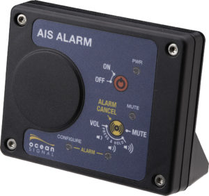
AIS Display: An AIS display interfaces with either a transponder or receiver to display the AIS radio signals in a useable format. A dedicated AIS display is very useful to allow critical safety information to always be available at a glance and can include features that aren’t normally found in plotters or computer programs. If the transponder or receiver is WiFi enabled, you are able to use your smart phone, tablet or computer as an AIS display.
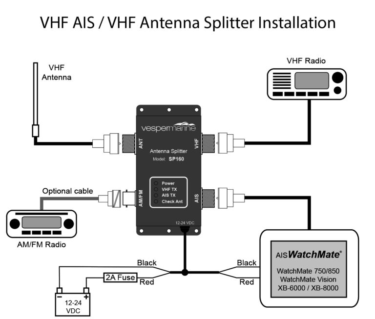
AIS Antenna Splitter: A dedicated AIS antenna is used to pick up and transmit AIS signals only. A AIS/VHF splitter can be installed in order to share an existing VHF antenna between your VHF radio and AIS transponder or receiver without transmission or reception loss to any devices.
How does AIS help avoid a collision with another boat?
Primarily used as a tool for collision avoidance, a correctly set up AIS display provides valuable data, most often in a graphical display, to the skipper to enable highly informed decision making. It must be noted that AIS is an aid a means of lookout and to identify the risk of collision rather than as an automated collision avoidance system, your seamanship and acknowledging the maritime rules still play a vital role! When a vessel is navigating at sea, the movement and identity of other vessels in the vicinity is critical for navigators to make decisions to avoid collision.
Visual observation (unaided, binoculars, night vision), audio exchanges (whistle, horns, VHF radio), and radar or Automatic Radar Plotting Aid (ARPA) are historically used for this purpose. However, a lack of positive identification of the targets on the displays, and time delays and other limitation of radar for observing and calculating the action and response of vessels around, especially on busy waters, sometimes prevent possible action in time to avoid collision.
While requirements of AIS are only to display a very basic text information, the data obtained is not typically integrated and/or overlaid onto electronic charts or a radar display, providing consolidated navigational information on a single display. This is where the integration and NMEA 0183 or 2000 networking compatibility between the AIS transponder and a vessels radar and plotter system is critical and an important consideration when choosing an AIS system.
Depending on the brand and model of AIS selected, manufactures such as Vesper Marine offer advanced AIS software with their devices to provide easy to use features including possible collision target filtering, collision alarms, operational modes (anchoring, offshore, inner harbour etc) , anchor drag monitoring and man over board functions.
AIS was developed with the ability to broadcast positions and names of objects other than vessels, such as navigational aids and marker positions. These aids can be located on shore, such as in a lighthouse, or on the water, on platforms or buoys. The ability to broadcast navigational aid positions has also created the concepts of Synthetic AIS and Virtual AIS. In the first case, an AIS transmission describes the position of a physical marker but the signal itself originates from a transmitter located elsewhere. For example, an on-shore base station might broadcast the position of ten floating channel markers, each of which is too small to contain a transmitter itself.
In the second case, it can mean AIS transmissions that indicate a marker that does not exist physically, or a concern which is not visible (i.e. submerged rocks, or a sunken, wrecked ship). Although such virtual aids would be visible only to AIS equipped vessels, the low cost of maintaining them could lead to their usage when physical markers are unavailable.
Search and Rescue
For coordinating resources on the scene of a marine search & rescue operation, it is important to know the position and navigation status of ships in the vicinity of the ship or person in distress. Here, AIS can provide additional information and awareness of the resources for on-scene operation, even though AIS range is limited to VHF radio range. The AIS standard also envisioned the possible use on SAR Aircraft, and included a message (AIS Message 9) for aircraft to report position.
Computing & Networking
Several marine Mac and PC programs are available for use with AIS data. Some programs can re-transmit the AIS information to a local or global network, allowing the public or authorised users to observe vessel traffic from the web.
Some programs display AIS data received from a dedicated AIS receiver onto a computer or chart plotter. None of these programs are AIS transmitters, thus they will not broadcast your vessel’s position but may be used as an inexpensive alternative for smaller vessels to help aid navigation and avoid collision with larger vessels that are required to broadcast their position.
Installation – VHF Antenna Considerations
Installing a Class B AIS transponder requires a VHF antenna that may be dedicated for the AIS or shared with the vessel radio via a VHF splitter. Some installations may require the addition of a separate GPS antenna to be mounted externally, however in many vessels, AIS transponders that feature an integrated GPS such as the Vesper Marine XB-8000 will negate the need for this.
There are trade-off’s between having a dedicated AIS antenna and sharing one with your existing VHF system through a splitter. A dedicated AIS-tuned antenna is an excellent choice and will typically out-perform a standard VHF antenna due to being tuned specifically for the high end of the VHF band where AIS is located. It can also serve as a backup antenna for your VHF. However, a dedicated antenna may be harder to install since you need to mount it and run the cable, etc. Look to place the antenna as high as reasonably practical but as far away from masts and other antennas, particularly other VHF antennas.
A splitter allows the use of an existing VHF antenna for an easier installation. If you decide to get a splitter, you must use one designed for AIS. If you have a transponder you must use a splitter designed specifically for use with AIS transponders.
However, your VHF antenna may not be well tuned at AIS frequencies and may lead to poor transmit performance. You can check your antenna performance at AIS frequencies by looking at the VSWR curves provided by the antenna manufacturer (they can sometimes be found on the manufacturers website). Look for a VSWR of 2:1 or less at 162MHz. Most VHF antennas are well tuned for 156MHz but will start to degrade at the extremes of the VHF band.