The Mahurangi Harbour and outlying islands to the east and northeast offer a diverse range of river, harbour, coastal and island experiences that cater to all sizes of trailer craft, cruising aspirations and pastimes. Geoff Green highlights the attraction, history and infrastructure of this popular cruising area, which borders New Zealand’s largest city.
The Mahurangi area took its name from the rocky island outcrop off Waiwera after early European seafarers and colonists applied the Maori name for this prominent coastal landmark to the harbour and river to the north. By providing a safe anchorage and an extended reach inland, the Mahurangi Harbour and river played an integral part in the region.s development. It formed a convenient link in early coastal shipping and passenger transport networks and facilitated the extraction of timber and lime reserves.

Kauri spars were felled by Mahurangi’s first European resident around 1832, and in 1840 Governor Hobson asked that it be investigated as one of four possible sites for New Zealand’s capital. Abundant supplies of kauri and pohutukawa fostered a shipbuilding industry (the Scott, Darrach and Darroch families were the mainstream builders), although the timber resources were quickly depleted and construction of coastal and ocean-going sailing ships withered when local timber supplies ran out around 1880.
Steamers on the Mahurangi
The first steamer called at the Mahurangi heads in 1855 and a regular run was established by paddle steamer in 1871, and the run was extended to Warkworth around 1875. The last scheduled commercial river service was withdrawn in 1937 and the substantial wharves that had been built at Scott’s Landing and Sullivans Bay fell into complete disrepair and were demolished. Scows continued to service Warkworth as demand required and the motorised scow, Owhiti, was the last to carry fertiliser up the river and casein down, in the mid-sixties.
Coastal development has surged ahead and the night-time aurora from Auckland’s expanding northern suburbs, the proliferation of Mahurangi lifestyle blocks andresidential developments radiating out from Warkworth are combining to encroach pincer-like on the harbour. However, four large Auckland Regional Council coastal parks, three Department of Conservation island reserves and large tracts of rolling farmland have kept suburbia at bay and the region still retains its cruising appeal.
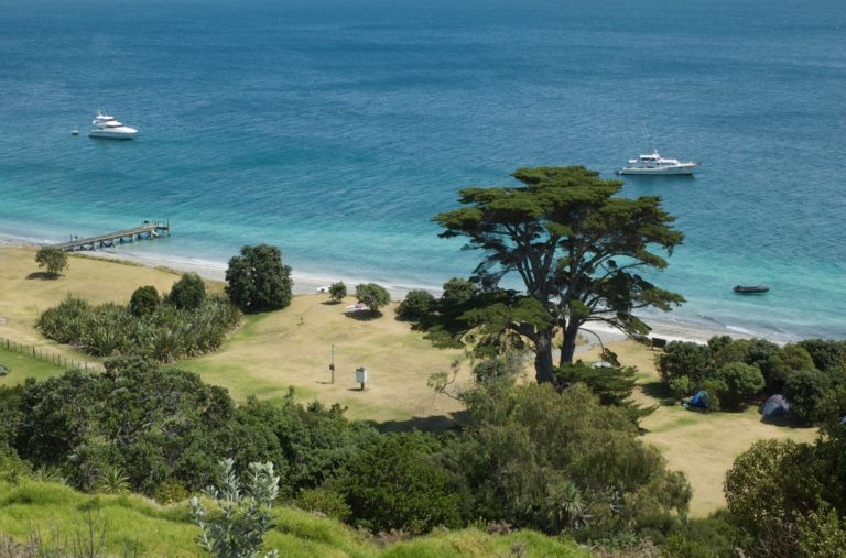
A positive aspect of the Mahurangi’s proximity to Auckland’s large population base is that it provides suburban and inner-city trailerboat owners the opportunity to quickly and safely de-stress without travelling too far from home or taking time off work; the Mahurangi area works well for day trips, overnighters and longer stays. Within the DoC reserves and ARC public park four attractive waterfront locations with basic camping facilities (drinking water, cold shower and clean long-drop loos), and one absolute prime location with a picture-postcard bach for rent, beckon cruisers operating out of boat that can be pulled up on the beach or left anchored in the bay. When sleeping aboard many bays within Mahurangi Harbour provide calm anchorage with secure overnight holding and even though a little more exposed to wind and an easterly roll, the outlying islands offer couple of anchorages that position cruisers far from the madding crowd (outside of peak holiday times) and provide a taste of paradise. Te Muri, on the mainland south of the Mahurangi Heads, is the area’s southernmost park with camping
facilities. It has a white sand beach that shelves gently to provide safe swimming and good holding, but it is exposed to any wind with an easterly component. There is an estuary at the northern end that will provide emergency shelter for a trailer boat when camping ashore, although it dries almost completely below mid-tide, is some distance from the camping ground and is on the walking route in and out of the bay. The beach is well protected from any wind from south through west to north. Te Muri can be accessed by walking in from the Mahurangi West road on the ridgeabove Sullivan’s Bay (about 15mins), or by boat. The closest launching ramps are at Wenderholm immediately to the south or Scott’s Landing on the northeastern shore of Mahurangi Harbour. Wenderholm is a tidal estuary (the channel leading to theupstream ramp is navigable to about half tide and slightly beyond), and being an ARC park with access from State Highway One, the gates close at sunset and don’t open until 8am. If you launch at Wenderholm don’t keep valuables in the vehicle because thieves prey on cars (this also applies to Scott’s Landing and the parking area that services Te Muri). Sullivans Bay (also know as Otarawao Bay) is adjacent to Te Muri but, because it is positioned inside Mahurangi Harbour, it offers superior shelter. It is the most developed of all the coastal parks and has easy road access but no formed launching facilities; vehicles are not allowed on the beach and small camping ground if you are completely self-contained (including ‘take-away’ toilet). Lagoon Bay is very tidal but it’s fine for camping expeditions using small boats (tinnies are ideal) and provides an emergency easterly weather anchorage for those staying in Big Bay. While a good portion of the headland is public parkland, the end is private property, although there is nothing to stop boaties using Dairy Beach below the high-water mark. Despite ongoing siltation the Mahurangi River remains navigable to the township of Warkworth. It’s an attractive town that was founded on the ability of scows and small ships to reach inland to service the timber trade, the farmland created after the natural forest was felled, and the lime industry. Warkworth was originally the site of a sawmill and then a flour mill – both powered by water wheels – and early lime kilns are situated about one kilometer from the river in what is now Kowhai Park.
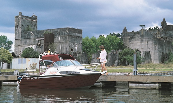
Lime Work Ruins
The burnt lime industry, which started around 1849, then cement production, played a significant part in the area’s prosperity, and the ruins of the largest factory are now a riverside landmark. Riverside evidence of other burnt lime production sites, and a tramway and an all-tide wharf used to service a major orchard operation that flourished around 1930, have long gone, although signs of a modified landscape remain. Thomas Wilson first quarried and burnt limestone on the site of the prominent riverside ruins in 1866 (the quarry is now a lake lined with rushes) and started making cement, which is more complex than hydraulic lime to manufacture, in 1885.
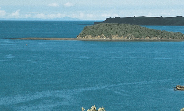
The calcium content of the quarried limestone was augmented by shell brought up the river by scow, as was coke and Westport coal to fire the kilns. At its peak, the factory produced around 125 tonnes of cement per week, but reverted to making smaller quantities of hydraulic lime in 1918 after a merger and rationalisation of plant to Whangarei, before closing in 1929. Many of the buildings were destroyed during demolition exercises conducted during World War II and the site is now a reserve, marina and haulout yard. The upper Mahurangi is tidal and estuarine and a trip to Warkworth should be planned to coincide around high tide. It’s an easy trip – allow 90 minutes from the heads to Warkworth – and the channel is reasonably well marked; there are no navigation issues for powerboats following the flood tide in and first of the ebb tide out. If maritime visitors want to stay in Warkworth longer than it takes to have a wander, meal and latte, the narrow town basin retains sufficient depth to overnight throughout a tidal cycle. For something a little different, trailerboat owners might like to plan to share an evening meal in one of Warkworth’s excellent restaurants with land-based friends, then wander back to the boat for a quiet night and a pleasant cruise back to the launching ramp the next day. Because the harbour is tidal and the land adjacent to deep water is administered as parks by the ARC, or is privately owned, or does not have road access, there is a noticeable lack of good launching ramps in the Mahurangi area. Scott’s Landing – named after Thomas Scott who constructed ships in the bay – is the best because it is centrally located within the harbour and useable at all but the lowest spring tides. It was once the site of a major wharf and the parking area is the wharf’s reworked base. From Scott’s Landing it is only 7 nautical miles to where the saltwater mixes with the fresh at the Warkworth rapids and a further 2 nautical miles to Saddle Island guarding the harbour entrance.
Motuora DOC Camping
Saddle Island has a sheltered beach on its western flank, but for those with island walks, swimming, beach camping and land-based or boat fishing uppermost in their minds, the camp ground at Motuora Island is a great place to start. The Department of Conservation administers Motuora and all pests have been eradicated and the largest exotic trees have been felled in preparation for re-afforesting the island with native species and restocking it with native birds, much the same as has occurred at nearby TiriTiri Matangi island park off the Whangaparaoa Peninsula.
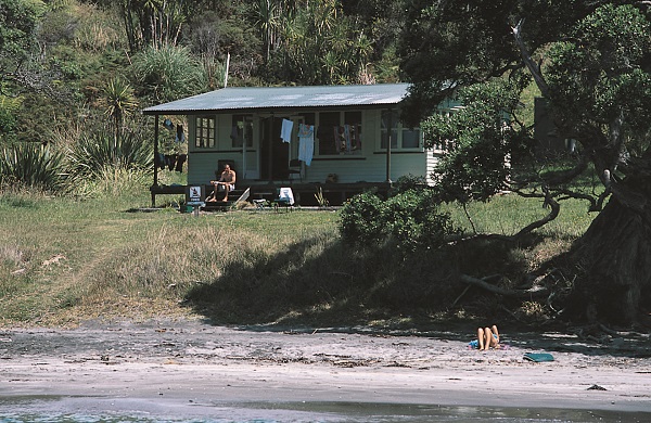
Motuora’s camping ground will accommodate up to 75 campers (no pets) and a small rustic bach is also available for rent, although sadly its days are numbered and it is due to be demolished because DoC is progressively scaling back its involvement on many Hauraki Gulf islands. The reafforestation society is taking a more active role in managing Motuora, and although the camping ground will remain operational, the bach is too old and too costly to keep maintained.
The camping ground beach is exposed to the northwest and north, and a northeasterly swell tends to suck around the curve of the island to put a wave ashore. There is a small wharf adjacent to the ranger’s house but it is not for public use and, besides, it’s only useful from mid-tide on, is exposed to waves and it is further to walk to and from the campground; it is just as easy to use the beach. Once I unloaded our crew and gear into the bach I anchored offshore and rowed back and forth in a 2.2 m inflatable. The holding is excellent in fine sand and many campers leave their boats anchored out for the duration of their holiday. The camping ground beach is one of two great beaches on the island. The other, found in a semi-enclosed bay towards the island’s southwest extremity, is much smaller but offers the advantage of being very sheltered in the prevailing south westerly wind. The bay will accommodate up to five or six trailer boats and although it is a great picnic spot, its tight confines and rocky shallows at low tide discount it as an overnight anchorage. Good snapper fishing is common around the islands and along the coast in spring,summer and autumn, and for those willing to put in the effort, an occasional crayfish can be found around the rocky outer islands and reefs.
Crays At Motuketekete
While undertaking a keep-fit snorkel to work off an excessive Christmas lunch I was pleasantly surprised to locate numerous crayfish less than twenty minutes swim from Motuketekete’s most popular bay. One was a jumbo model that generated an adrenaline surge that temporarily suppressed my urge to breathe, and of course I ended up rocketing to the surface gasping for air. However, I did get a fleeting grip to one horn, but the cray’s physical attributes were matched by the twisting restrictions of the hole it occupied and I am happy to say it still lives there to breed and evade divers another day (hopefully).
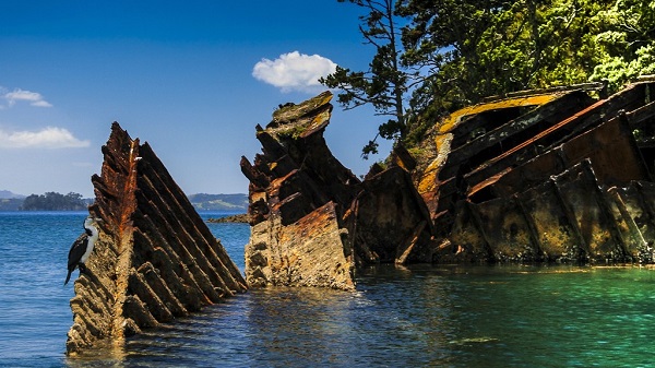
Not too many years ago I snorkeled scallops off Moturekareka, although continuing diving pressure means they are now few and far between. Moturekareka is the last resting place of the 3000 tonne sailing ship Rewa (formerly Alice M. Leigh), which was scuttled to form a ‘boteld’ and breakwater around 1930, although it settled in the wrong place and the resulting ‘harbour’ is rather small. It will accommodate six or seven trailer boats at low tide but bow and stern anchors are required to control the swing. Although Rewa is now reduced to a rusting, partially collapsed shell, it was sunk fully equipped and rigged (including the table napkins!) and many of the masts and spars fell away from the shore out to sea. The wreckage on the seaward side is an interesting place to snorkel and I have seen many snapper in amongst the tangle. As far as easily accessed and sheltered cruising areas go, the Mahurangi Harbour and its adjacent islands have a lot to offer. Trailer boat cruisers can enjoy a double-espresso wharf side buzz in Warkworth, catch 40-winks under a secluded coastal pohutukawa, snorkel an impressive wreck, and have a realistic expectation of dining on fresh seafood while anchored in any number of beautiful coastal and island bays.
The historical aspects of this feature referenced R. H. Locker’s Jade River – A History of the Mahurangi, and The Rock and the Sky – A Story of Rodney County, by H. Mabbett.